
Inland Villages
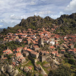
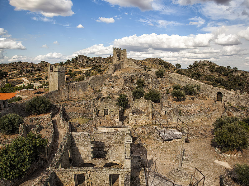
Marialva (Mêda)
Human presence in Marialva is ancient. It was called Civitas Aravorum (City of the Aravi) by the Romans, later São Justo by the Goths, then Malva by the Arabs, and finally renamed Marialva by Ferdinand the Great of León (Castile) in 1063.
Afonso Henriques found it abandoned and ordered its repopulation, granting it a charter in 1179. During the reign of King Dinis, it received a three‑day fair on the 15th of each month (1286), as well as some works on the castle. It was granted the title of county in 1440, with Vasco Fernandes Coutinho becoming the first Count of Marialva. Later, it was elevated to a marquisate, granted to António Luís de Meneses, who already held the title of Count of Cantanhede. After the attempted regicide, the village fell into disgrace and abandonment, as its mayor at the time was the Marquis of Távora. It remained a municipal seat until 1855.
Marialva consists of three distinct areas: the Citadel – the village within the castle walls; the Arrabaldes – the outer village beyond the walls; and the Devesa – the fields stretching to the Marialva stream. Inside the walls (though in ruins), one can still see the granite Portuguese pavement, the pillory, and the remains of several buildings.
Points of interest: Castle, Pillory, Former Town Hall (Court and Jail), Church of the Misericórdia (or Church of Senhor dos Passos), Parish Church (Church of Santiago), rock‑cut tombs, Casa do Leão, Manor of the Marquises of Marialva, among others.
Penedono
Penedono is not part of the official Historic Villages network, but it could easily be included. The foundations of its beautiful castle date back to the 10th century (although its current form is from the late 14th century). Over the years it was abandoned and left in ruins until 1940, when major restoration works were carried out on the walls and towers, leaving the interior still empty.
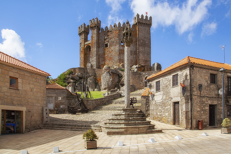
The name likely derives from Pena do Dono, meaning Rock or Castle belonging to Dono, a common surname in the 10th century.
The town is situated on a hill on the border of the Beira region and has a medieval urban layout arranged around the castle, which crowns the highest point of the historic centre.
Points of interest: Castle, Clock Tower, Penedono Interpretation Centre, Pillory, Town Hall, Clock Tower (Solar dos Freixos), Parish Church of São Pedro, Chapel of São Salvador, Calvary Chapel, Chapel of Santa Bárbara, 16th‑century Fountain, Immersion Fountain, among others.
Trancoso
A city located between the Douro, Côa, and Mondego rivers, it was an important and highly contested stronghold even before the foundation of Portugal. Ferdinand the Great (King of León and Castile) repopulated the settlement in 1033 and later integrated it into the Kingdom of Galicia.
In 1139, the Arabs returned and took the city, destroying the walls, but their occupation ended definitively with the conquest of Afonso Henriques in 1160, who granted it a charter. This was later confirmed by Afonso II, allowing the reconstruction of the walled perimeter.
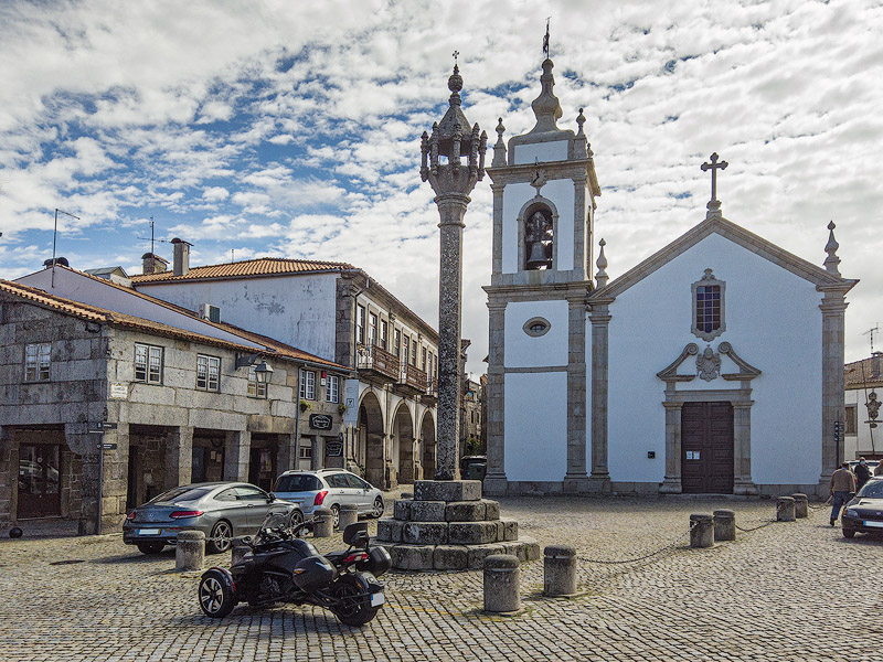
With intense commercial activity and rapid development, Afonso III took interest in Trancoso, creating the Trancoso Free Fair, held annually. In 1306, King Dinis followed the model and created another monthly fair lasting three days. Even today, Trancoso’s fairs play an important role, attracting many visitors every week, with the New Year Fair being the most popular.
The city was chosen as the venue for the marriage of Isabel of Aragon and King Dinis (who expanded the walls), a clear sign of its importance. Over the centuries, many events and notable figures contributed to its prestige, and it was elevated to city status on December 9, 2004.
Points of interest: Castle, Castle Gates, Walls, Casa do Bandarra, Church of São Pedro (Bandarra’s tomb), Church of Nossa Senhora da Fresta, Isaac Cardoso Jewish Interpretation Centre, Poço do Mestre, Jewish Quarter, Casa do Gato Preto, Chapel of São Bartolomeu (tile panel of the Royal Wedding), Trancoso Pillory, Rock‑cut Tombs, among others.
Linhares da Beira (Celorico da Beira)
It is believed to have originated from an ancient hillfort dating back to the 1st century, but its name almost certainly derives from the flax fields (linhares) once found here.
A strategic lookout point, it was occupied by Visigoths and Muslims before becoming part of the Kingdom of Portugal under Afonso Henriques, who granted it its first charter in 1169. The first historical reference to the castle dates from the late 12th century, during the reign of Sancho I, when the brothers Rodrigo and Gonçalo Mendes were the mayors of Linhares Castle and Celorico Castle, respectively.
History tells that when Celorico was besieged by the forces of León and Castile, Rodrigo came to its aid, attributing the victory to Our Lady of the Açores, to whom a chapel was built halfway between Celorico and Linhares.
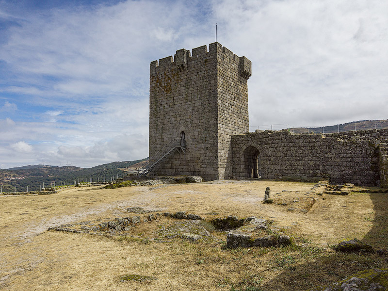
With the borders established, Linhares continued to hold strategic importance until the 17th century, as it formed part of the defensive system of the Mondego basin, behind the fortifications of the Beira border.
With peace in the kingdom, the castle lost its relevance and fell into ruin. Only after being classified as a National Monument were major restoration works undertaken over several years, restoring its majestic appearance.
The village is located on a slope of the Serra da Estrela, with the castle perched on a rocky hilltop (around 2,690ft820m altitude) and the settlement extending to the South.
Points of interest: Linhares Castle, Parish Church of Nossa Senhora da Assunção (Romanesque, with 3 works attributed to Grão Vasco), Church of the Misericórdia, Pillory, Former Town Hall (Court and Jail), Immersion Fountain and Forum, Solar Corte Real (18th century), Solar Pina Aragão (16th century).
Belmonte
Like most others, the village of Belmonte stands elevated on the scenic Monte da Esperança (formerly the Crested Hills).
Human occupation here is believed to date back to prehistory. Sancho I ordered its repopulation, granting its first charter in 1199. Years later, the castle was built, and by then two churches and a synagogue already existed.
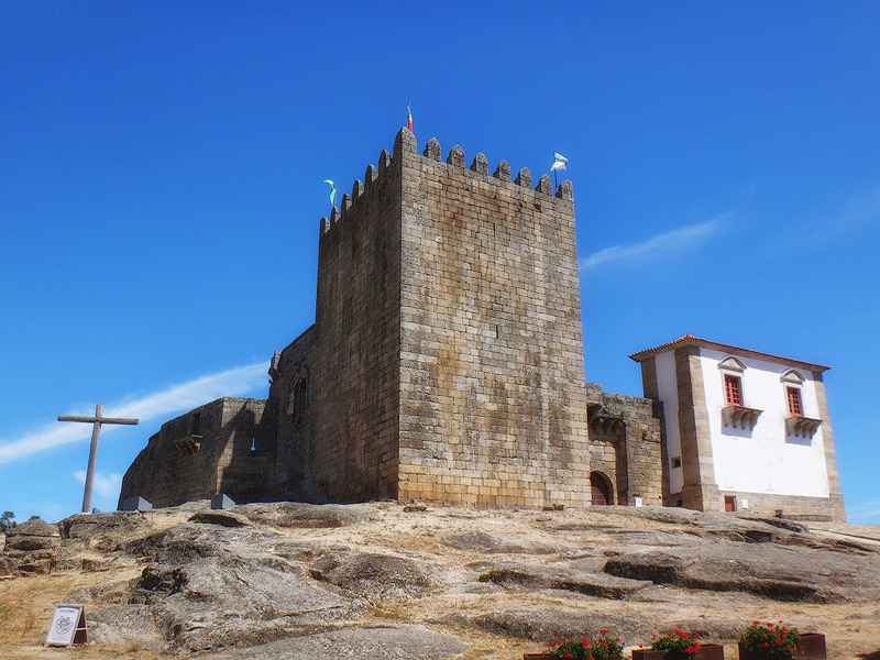
In the 15th century, the castle and its revenues were donated hereditarily to Fernão Álvares Cabral. Belmonte is the birthplace of the navigator Pedro Álvares Cabral (Fernão’s son) and is also closely linked to the history of Sephardic Jews, especially with the settlement of the Marranos.
The persecution of Jews by the Inquisition in the Iberian Peninsula forced many to flee or convert to Christianity. Those who remained in Belmonte formed a crypto‑Jewish community that maintained its religious practices in secret, only publicly acknowledging them in 1920.
Points of interest: Castle, Centum Cellas Tower, Parish Church of the Holy Family, Church of Santiago, Calvary Chapel, Chapel of Santo António, Synagogue.
Piódão (Arganil)
Located in the Serra do Açor, it differs from all the others for not having walls, a castle, or any military architecture. It is the westernmost of all the villages and therefore was not a territory of dispute. This does not make it any less ancient, as the settlement likely originated in the Middle Ages. It is estimated that in the 13th century, Lusitanian shepherds settled here, seeking the fertile watercourses of the mountains.
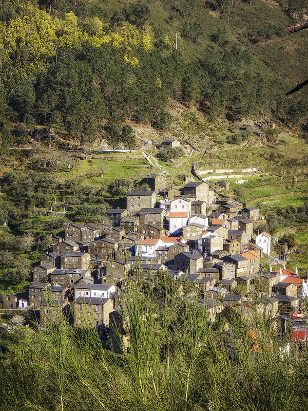
Piódão has no castles, but it has plenty of schist (the region’s predominant stone), which earned it a place among the most iconic Schist Villages. It often appears as the postcard image of the Schist Villages, with its countless schist houses featuring blue‑painted doors and windows arranged amphitheatrically on the slopes of the Serra do Açor.
Points of interest: Piódão Museum Centre, Parish Church of Nossa Senhora da Conceição, Chapel of São Pedro, Chapel of the Souls, Piódão River Beach, PR2 ARG hiking trail “The Peoples of the Piódão Streams” (10 km or 6 km for PR2‑1).
Castelo Novo (Fundão)
Located at 2,133ft650m altitude on a slope of the Serra da Gardunha, it has a well‑preserved urban structure and a concentric layout crowned by the castle, typical of a medieval village.
Its origins are also very ancient, with human presence estimated since the Copper Age.
Although settlement is documented since the foundation of the Portuguese nation, the first charter was only granted in the early 12th century to the Templar Knights or to Pedro Guterres, its first mayor.

Originally called Alpreada, its name changed to Castelo Novo (meaning New Castle) — in contrast to a Castelo Velho (Old Castle) nearby — when Pedro Guterres donated the lands to the Templars after building the castle.
King Dinis granted its second charter, and later the castle was restored by order of King Manuel I, who also granted its third charter in 1510. It remained a municipality until 1835, when it was integrated into Alpedrinha, and later both were incorporated into the municipality of Fundão.
Points of interest: Castle, Archaeological Centre of Castelo Novo, Former Town Hall, Parish Church of Nossa Senhora da Graça (18th century), Church of the Misericórdia (17th century), Chapel of Santa Ana (16th or 17th century), Chapel of Santo António (16th century), Chapel of São Brás (16th century), Chapel of Senhor da Misericórdia (17th century), Pillory, Lagariça (7th or 8th century), King’s Fountain (14th century), Bica Fountain (18th century), River Beach
Leave a message