The Pueblos
Arcos de la Frontera
It is at the western end of the mountain range and positioned on a meander of the Guadalete River. The old part of the city (casco antiguo) is located on top of a cliff (Peña de Arcos) about 320ft/100m high, with a fabulous view that can be appreciated from the Balcón de la Peña Nueva viewpoint.
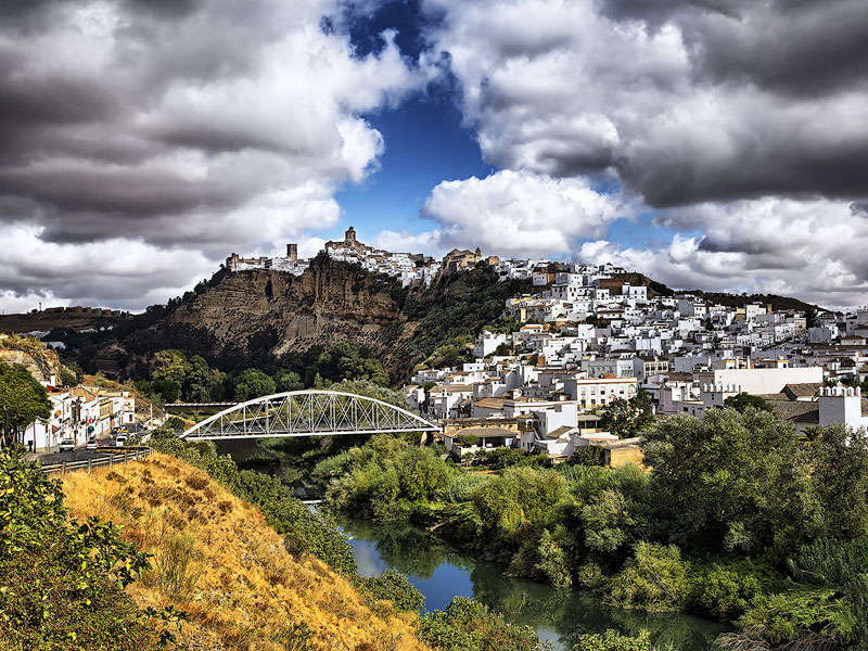
The labyrinthine urban layout, the wall, and the alcázar (which gave rise to the castle) date back to Arab occupation. Arcos expanded along the slope of the cliff, suffering from the 1755 earthquake which forced the reconstruction of many buildings. It belongs to the list of "Most Beautiful Villages of Spain".
Nearby points of interest: Plaza del Cabildo, Balcón de la Peña Nueva, Minor Basilica of Santa María de la Asunción, Palace of the Count of Águila, Matrera Gate.
Casares
The typical postcard village that can be seen immediately upon arrival from the viewpoint at the entrance (on clear days it is possible to see Gibraltar from here).
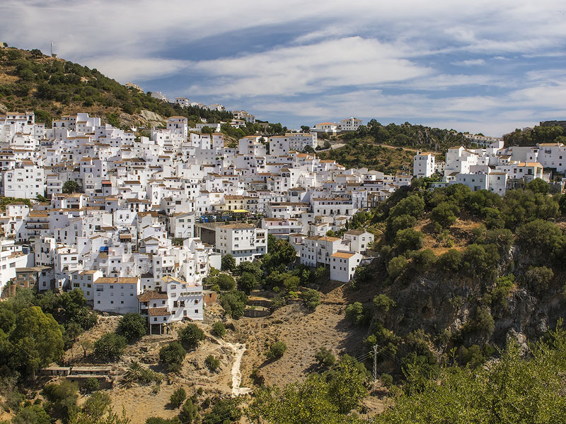
The pueblo of Casares is spread across a more or less steep hillside, and although there are prehistoric traces of human presence, it was established in the time of the Iberians and Phoenicians (3rd century). It was occupied by the Arabs and repopulated by Christians after the death of Al-Fair, leader of the Moriscos (16th century). Casares managed to resist the French Invasions without ever surrendering the village to Napoleonic troops. It is the birthplace of Blas Infante, an important lawyer, politician, and writer, author of the famous Ideal Andaluz (1915), a publication dealing with the historical and social issues of Andalusia.
Nearby points of interest: Birthplace of Blas Infante, Church of la Encarnación, Hermitage of San Sebastián, Torre de La Sal, Roman baths of La Hedionda.
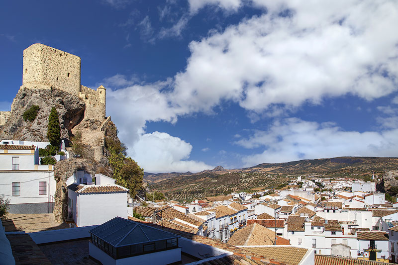
El Gastor
It is located on a slope of the Algarín mountain (3,470ft/1,060m), where traces of human presence dating back to prehistory have been found. It was a military stronghold before being taken by the Arabs and reconquered by Rodrigo Ponce de León (Duke of Arcos and Marquis of Cádiz).
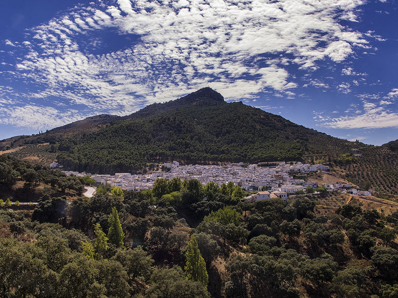
From that time it became a settlement and began to develop around the fountain on the main street (Calle de la Fuente, the first and oldest). It was always dependent on Zahara de la Sierra, with which tensions arose, becoming autonomous in 1834. There are reports that it was a refuge for the famous bandit José María "El Tempranillo", who dominated the mountains. Until the 20th century the village was quite isolated, without any paved road reaching it.
Nearby points of interest: Plaza de la Constitución, Church of San José (18th century), Molino Museum, Museum of Popular Customs José María "El Tempranillo" (located in the house of his lover).
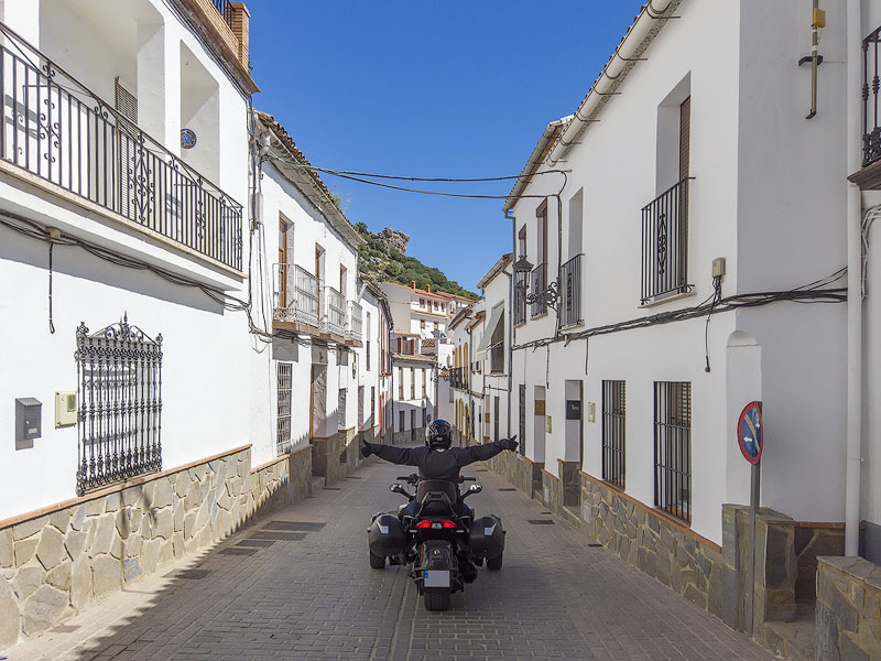
Gaucín
Located in the Sierra de Ronda, it is a very old place with a probable Roman origin. It has a castle whose first constructions date back to Roman times, but its current appearance was given during Arab occupation.
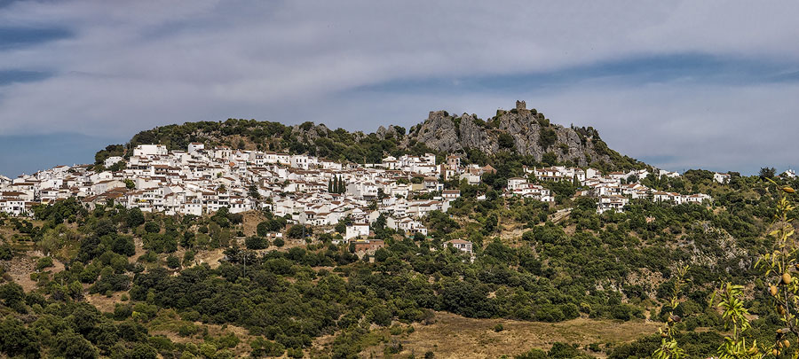
The village is nestled on a mountain slope surrounding the Genal River. The typically Moorish layout consists of a tangle of narrow streets adapted to the terrain. Its geographical location makes the southern and eastern sides of the village form a kind of balcony overlooking the mountains.
Nearby points of interest: Church of San Sebastián (16th century), Convent of the Carmelites, Fountain of the Six Spouts.
Grazalema
It is the village that gives its name to the mountain range where it is located. Of Arab origin, it was conquered in 1485 by Rodrigo Ponce de León (Duke of Arcos and Marquis of Cádiz).
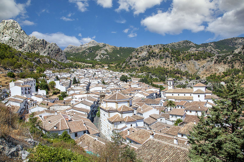
It reached its economic peak in the 17th century with the textile industry and the famous Grazalema wool blanket. During the industrial revolution of the 19th century, textile production declined, and Grazalema began exporting labor instead of blankets. A curiosity: it is the municipality with the highest rainfall in all of Spain (77in/1,962mm average annual precipitation, with a maximum recorded of 170in/4,343mm).
Nearby points of interest: Hermitage of Nuestra Señora de los Ángeles, Grazalema Town Hall, Church of San Juan, Textile Museum of the Grazalema wool blanket.
Júzcar
It is known as the Village of the Smurfs and unlike the others, here the houses are mostly blue. Júzcar was once a Pueblo Blanco, but on June 16, 2011, the village was chosen for the world premiere of the film The Smurfs. At that time the event’s promotional agency had the idea of painting the houses blue.
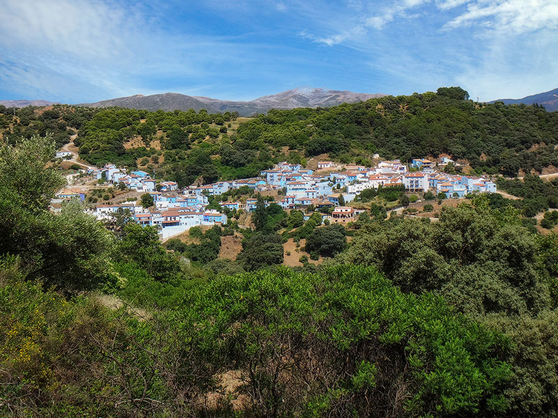
At the end of that year a public consultation was held, and the inhabitants decided to keep the blue façades, finding economic and recreational advantages over the traditional white lime. In addition to the blue color, there are several sculptures and other references to the Smurf characters. It is worth a visit for its original theme.
Nearby points of interest: Torrichela viewpoint, Church of Santa Catalina de Siena (16th century), Smurf market on weekends.
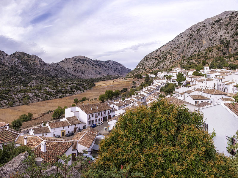
Montejaque
Its territory extends through the valley of the Guadiaro River and the Sierra del Líbar. It has Arab foundations, from which also comes the name believed to mean "lost mountain".
The village is divided into two areas: "el castillo" or the upper neighborhood in the highest part, composed of narrow and disorganized streets (older, of Arab origin), and the lower neighborhood with parallel and symmetrical streets (more modern). It has managed to counteract depopulation through nature and adventure tourism, made possible by the various hiking trails and caves in the region.
Nearby points of interest: Plaza Mayor, Church of Santiago el Mayor (16th century).
Olvera
The origin of this place is not clear but probably dates back to the Celts, with the castle foundations (today in ruins) pointing to Roman occupation. What is certain is the Muslim presence between the 12th and 14th centuries. After the reconquest it became part of the Duchy of Osuna.
Olvera is surrounded by olive groves that produce one of the best olive oils in Andalusia. Its name also comes from this after the Christian reconquest. It gained the title of city in 1877 for providing horses to King Alfonso XII during the Carlist wars. From the church of Nuestra Señora de la Encarnación and next to the ruins of the old castle, it is possible to enjoy a magnificent view of the city. The neoclassical church was built on the foundations of a Gothic-Mudejar church
Nearby points of interest: Ruins of the Olvera Castle (12th century), Church of Nuestra Señora de la Encarnación.
Setenil de las Bodegas
It is outside the mountain range to the north of Ronda and stands out for being embedded in the valley formed by the Trejo River, which crosses it. Historically, the Christian reconquest of Setenil was fundamental for the advance of the Spanish crown towards Granada. The city was considered impregnable, and it is said that it was besieged seven times (the last in 1484) before being taken, from which its name derives (Septem nihil).
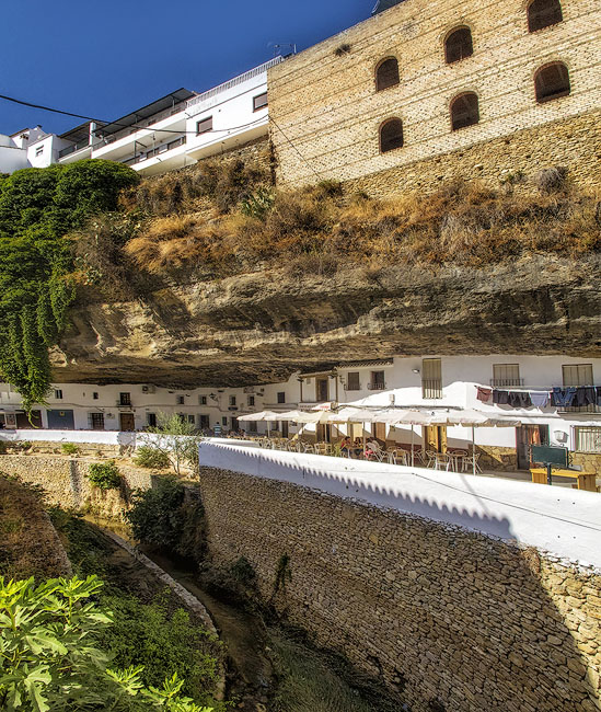
Its importance is attested by the presence of the castle (a Nasrid fortress with about 40 towers), a hospital, a seminary, and an important church. The church of Nuestra Señora de la Encarnación stands out for combining two architectural styles – Mudejar and Gothic. The main attractions are the cave streets of the Sun (Calle Cuevas del Sol) and of the shadow (Calle Cuevas de la Sombra). Both are located inside caves in the valley walls, which narrow in this area. They run parallel and next to the river, with the first on the north bank and the second on the south bank. The effect is fantastic, especially because of the houses that were carved into these walls.
Nearby points of interest: Calle del Sol, Calle de la Sombra, Setenil Castle (13th century), Church of Nuestra Señora de la Encarnación (15th century), Hermitage of San Sebastián (15th century), Hermitage of Nuestra Señora del Carmen (18th century), Hermitage of San Benito (15th century), Hermitage of Nuestra Señora de la Concepción (18th century), San Román caves (16th century).
Ubrique
It was reconquered from the Moors in 1490 by Rodrigo Ponce de León (Duke of Arcos and Marquis of Cádiz). Since the 18th century, several leather factories existed here, following the Muslim art of leatherwork (marroquinería). Today it is one of the main leatherworking centers in Europe.
Nearby points of interest: Town Hall, Castle of Fátima, Church of Capuchinos (17th century), Church of Nuestra Señora de la O (18th century), Church of Jesús (17th century), Church of San Antonio, Leather Museum.
Villaluenga del Rosario
It gained some notoriety for the production of payoyo cheese – made from the milk of goats of the same name, native to these lands. It is located near the Sima de Villaluenga, about 650ft/200m deep and extending over more than 1.8mi/3km of galleries.
A curious and notable place is the cemetery located in the village, known as one of the most beautiful and photogenic in Spain. It is inside the church of El Salvador, whose roof was destroyed in 1808 by Napoleonic troops. On clear days the Sun illuminates the garden inside the nave, creating a unique picturesque effect.
Nearby points of interest: Cemetery of Villaluenga del Rosario, Church of San Miguel, Hermitage of El Calvario.
Zahara de la Sierra
It is located on a slope of the Sierra de Grazalema, overlooking the beautiful turquoise waters of the Zahara-El Gastor reservoir. It is one of the few villages that still preserves the ruins of a castle.
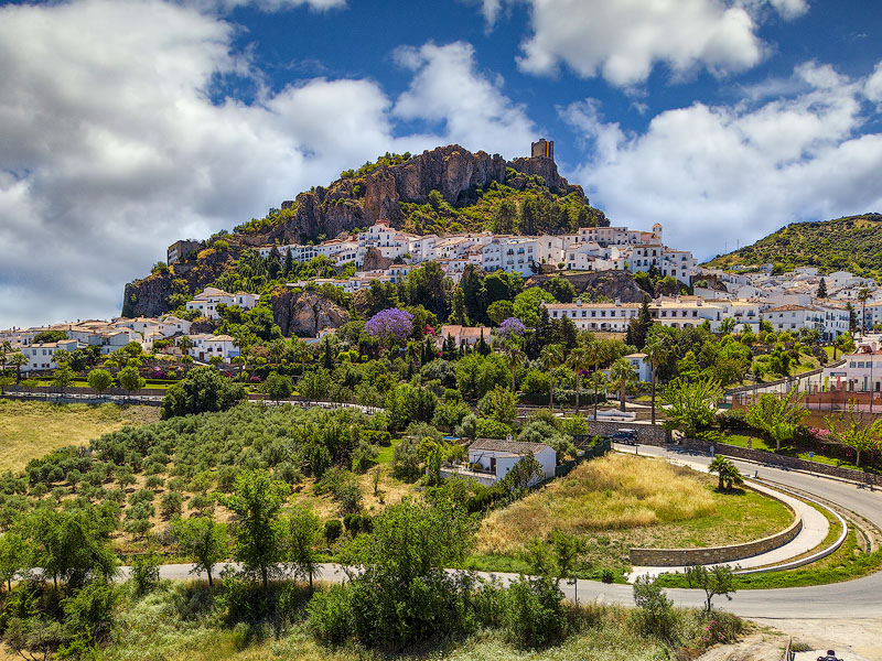
Of Arab origin, it is believed to have been an important city during the Moorish era. The castle is also from this period, having been conquered by the Christians in 1483, with the lion on the tower’s coat of arms representing the conquest by Rodrigo Ponce de León (Duke of Arcos and Marquis of Cádiz).
Nearby points of interest: Castle, Ruins of the main church, Church of Santa María de la Mesa, Chapel of San Juan de Letrán.
Leave a message